In the west, many of the states went through several migrations before taking on their current shape, size, border position, etc. The history of these events, and the impact made by these changes, can still be felt today.
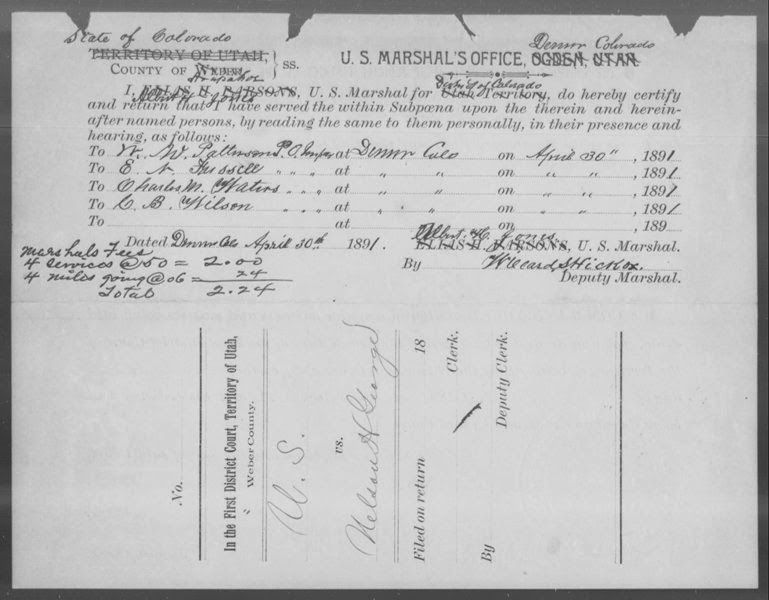
Take a look at this particular document. This is from the Territorial Case Files of the U.S. District Courts of Utah 1870-1896; NARA (Publication number M1401; digitized and available on www.Fold3.com).
The document is dated April 30th, 1891. It's a mess, isn't it?
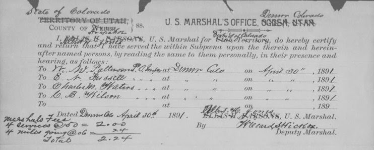
Let's take a closer look at the details in the top half.
This is a statement from the U.S. Marshall's Office in Denver, Arapahoe County, Colorado, stating that subpoena's had been issued to four men:
- C.B. Wilson
- Charles M Waters
- E.N. Fussell
- W.W. Patterson
But.. wait. This is from the Territorial Case Files of the U.S. District Courts ofUtah collection. Huh?
It goes on to indicate, in the handwriting in the lower left corner, the Marshal's Fee's for this service, a total of $2.24. Of course, you see immediately that every indication of the record being made in Utah is crossed out, and Colorado information is hand written over the top.
It's a great document, and an even better clue for anyone researching these families. There are a few different ways you could continue to research this... why were they subpoenaed? Do court records exist? Where else does this paper trail go?
I actually found this piece while conducting a search to identify what collections Fold3.com has that relate to Colorado in general. I was not searching for any of the names listed on the document, nor was I even digging for specific information made available on this record. I was searching Fold3.com for all available records for Colorado. These came up because they were every word indexed.
Let's back up for a second, and give a short history. Nearly half of what we know now as Colorado was once part of Utah Territory, essentially everything from the Continental Divide west. Utah Territory was formed in 1850, and this portion of it was formed into six counties in 1852. For those of us researching the western part of the state in the very early days of the gold rush, this becomes important, as some of the gold camps were established while the area was still part of Utah Territory. Breckenridge in current day Summit County is just one example of this. Colorado Territory was not established until 28 Feb 1861.
All of this leads to the question: why are the folks in Denver in 1891 using a form from Utah?
This record was produced thirty years after Colorado became its own designated dot on the map. Arapahoe County was one of the original seventeen created in the state, also. Certainly they would have had their own forms printed by then? We can make guesses as to why they were using this particular form (and by the way, this isn't the only record like this in the collection, there are a handful more that use the same form from Utah), but I think it's more important just to realize that they did in fact use these forms.
You can tell where I'm going with this, right?
It is vitally important to search in a variety of ways to find the information you are looking for. You never know what you might find when using a different key word, wild card search, or something beyond a surname.
Originally published 13 Jan 2014.
http://ancestralbreezes.blogspot.com/2014/01/where-in-world-is-colorado_13.html


 RSS Feed
